Garsdale Head to Sedbergh
- Dave
- Aug 17, 2019
- 10 min read
Updated: Jan 21, 2020
Pennine Journey – Day 15 – 13.75 miles
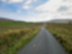
9.30am and I'm on the road. The sun’s already high, sky blue but for mare’s tail wisps unfurling far above.
Past Lunds Viaduct, over the railway line and onto the open moor, unseen skylarks issuing melodies to no-one but the sheep and a fell pony on faraway Turner Hill.
A short leg to the enchanting market town of Sedbergh on another perfect spring day! Life didn’t – couldn’t – get much better.
More than that, the single potential downer on the day – a lonely moorland crossing between Baugh Fell and adjoining Swarth Fell, linking the remote valleys of Grisedale and Uldale that Davd and Heather Pitt warn is not in evidence on the ground – is everywhere clear. Though I don't pass a walking soul all day, plenty of folk are clearly making this lonely upland pilgrimage.
So I stride out and join the skylarks in song, a sweet mountain breeze billowing in this lone walker's sails.


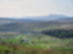
The Pennine Journey contours above the hidden valley of Grisedale, a cul-de-sac upland bowl sandwiched between Wild Boar Fell to the north and Baugh Fell to the west.
Terracing above it on the flanks of Grisedale Brow there's little to catch the eye: it's a landscape of rough Pennine pasture and straggled streams dotted with a few scattered farm buildings. But this backwater valley has exerted a pull on the public imagination for decades as 'The Dale That Died'.
AW notes as much in Walks on the Howgill Fells, writing that "at the turn of the century this pleasant valley was the home of a hardworking and happy farming community... Today it is a graveyard of ruined farmhouses." In a page-long meditation on loss he describes "good pastures turning sour" and "paths overgrown". Mourning the passing of a once-vibrant community and the yielding of many of the great farmsteads to "hard economic facts" he notes that "only one farmer still calls it home".
AW was writing in 1972, just three years before another chronicler of Pennine life, Barry Cockcroft – producer of Too Long a Winter, the documentary that made a star of Baldersdale farmer Hannah Hauxwell – turned his sights on Grisedale in a Yorkshire TV documentary accompanied by a book entitled The Dale that Died.
The Dale that Died centres on the one remaining farmer that AW describes, 61-year-old Joe Gibson, who laments: "I thought there was a great future in these hills... I cannot see any future now."
Fast forward half-a-century and neither AW nor Joe Gibson's fears have been realised.
While some of the valley's more distant dwellings – Round Ing, West Scale, East Scale – are footnotes in history, the majority have been given second lives, the chapel that was boarded up in the '70s (AW notes "even God has been driven out,") has been converted into a holiday let and, perhaps most poignantly of all, Joe Gibson's meadows are now being farmed by his grandson, Matthew Gibson... who still lives at Mouse Syke Farm.
It’s easy to come down hard on second homers, on holiday lets, and the money bought in by so-called offcomers, but in valleys like Grisedale new generations can offer a reprieve – a second wave of investment and people to rebuild and repopulate these once-fine buildings.
It’s not the grandest of valleys; and at Flust the chickens picking through the dirt, the cobbled-together gates and a few weather-beaten larches around a crumbling barn speak of poverty from a bygone age – is someone really living up here? – but Wainwright’s deathknoll seems stayed.
For a while longer, anyway.
(For those interested in such things, the twin farms of West Scale and East Scale – nearly the end-of-line dwellings in this most remote of valleys, and falling by the year – are almost certainly owned by synth-pop legend and Erasure co-frontman Vince Clarke. He bought them in 2000/2001, along with a sizeable tract of land alongside, with a view to building a recording studio and accompanying dwelling. The proposal was given planning consent by the Yorkshire Dales National Park, albeit with a list of 44 conditions, and work was seemingly started on the renovation before being abandoned. A friend told the Evening Standard "he ran out of money before work could start and he ';moved to New York". Moss now grows over piles of neatly stacked breeze blocks. Subsequent attempts to sell the properties have failed, meaning it is likely Vince still owns 80 acres of upper Grisedale. There's some fascinating research on this unlikely detail in the valley's history here.)


Onto the open fell, the looming bulk of Baugh Fell rising southwest across a thousand-acre lagoon of mire and, north above Nettle Brow, the curves of Swarth Fell. I reach for the camera and look for an angle; but there’s nothing to hold the eye, no features bar a faraway line of summit cairns; no trees, no crags, no sheepfolds. Just moorland grass, rush and the occasional sink hole.
Then I see the cows.
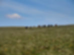
At first they’re a long way off; half a kilometre, maybe more.
No problems, I think, keeping a wary eye out. But with no walls to jump over or woodland to get lost in it’s a very wary eye.
As I continune through the rushes a cow raises its distant head to eye this newcomer on the moor. And because they're inquisitive souls, with a highly refined herding instinct, soon they're all eyeing me.
I contiinue onwards, less confident now, until I am forced to do a swift military-style assessment.
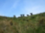
They’re moving now. Towards me. En masse. First with lazy gait. Then with speed, until all 20-or-so of them are lolloping six-astride.
My eyes scope the upland prairie for any kind of hiding place.
There's nothing but a shake hole 100 feet off.
So it is that, out of options, I surrender to my fear of the bovines and run for the hole, making a 30 foot plunge moments before my moorland adversaries arrive.

I look upwards at the rim of the hole.
First one face, then three, then all 20-or-so of the cows gaze down.
The hole sides are too steep for the cows to descend, but not steep enough to stop me climbing out. My plan is a waiting game. They’ll get bored long before I will, and shortly after they saunter off, so will I.
I survey the hole.
In the whole of my hole there are a few thousand blades of moor-grass, a partly exposed slab of limestone and then, at the bottom, a damp secondary hole, plugged by a boulder. I don’t get too close. It would be unfortunate to have adopted an as-yet undiscovered pothole leading into the cave network below. Being swallowed, Pit of Sarlacc-style, on this unlovely stretch of hillside doesn't feel like the heroic kind of ending I might have planned.
The sun's strong and the air heavy.
I consider my options. Shouting for aid will have no benefit. The number of visitors making the lonely trek to Uldale is likely no more than a couple each week. Besides, I'm a long way from the path now; on Homes Moss there's no-one to hear you scream.
I consider calling Terence, my farming buddy who I've arranged to meet near Sedbergh later in the day. He would know what to do.
Or I could call Mountain Rescue for the most embarrassing Uldale callout in history.
Or I could simply call a friend for a chat until the proverbial cows go home.
But there's no phone signal, of course.
The flaw in my plan, I slowly realise, as the minutes creep by, is that the cows are showing no interest in leaving. Instead they stand at the top of the hole, looking down at this odd moorland creature, flicking their tails, munching the grass and occasionally mooing.
I’m in for a long stretch. That much becomes clear.
So I get out my cheese sandwich. I ration it carefully; who knows what time my self-imposed imprisonment will end?
Then I do a forensic survey of the map. Partly to pass the time, partly to see if there’s anything I missed first time around – a hiding place I might escape to on my onward journey.
But no, nothing. The fence that will secure me from the beasts lies a mile off.
So I get out my copy of AW’s Pennine Journey and have a read as the cows continue their guard.
I check my phone.
40 minutes has passed.


An hour now has passed in my hole on the hill.
The cows have skirted around the edge of the hole but not moved a lot. Some have drifted away, but most still stand there, mooing and munching and staring at me.
In the end it is boredom that solves the impasse.
You can tell the cows are getting bored by the fact that they start trying to mount each other. Cue assorted protests and ton-heavy packs of meat lolloping around the crater of the hole. (Please don’t fall in, I pray. It would be the most unkind irony for a vegetarian to die beneath a cow that fell in a hole after an attempted moorland liason).
Soon the humping becomes more commonplace. A few faces disappear from the rim and the moos become more muted. One stubborn bullock sticks around, eyes pinned to me. But soon even he gets bored.
I shuffle up to the rim of the hole and peep carefully though the maron grass at my bovine foes as if on an army field exercise. They are close by, but they have started moving across the moor.
The heat is blazing now, sun at its highest in the early afternoon sun. An hour-and-a-bit wasted, and I'm still eight long miles from Sedbergh. My airy morning tramp, in fine voice, feels like it happened yesterday.
I return to Wainwright.
And when I turn the last page of the Pennine Journey I make a decision.
I also am bored. And – honestly – I’d rather say goodbye under the open skies of the cattle prairie than hang around a minute longer in the hole.
So, throwing caution to the walkers' wind, I pull on my pack, climb into the open air and stride on.
Of course the cows barely give me a backwards glance.


It’s still a distance to Sedbergh.
I’d assumed once over the moorland pass into Uldale I’d be in for a level valley romp.
But it’s not to be.
Instead the wander along the base of the Howgills is something of a topographic rollercoaster, though with scenery this grand – whaleback ridges of Wandale Hill, Yarlside and the Calf above a wooded dale cut by the Rawthey – the miles fall quickly.
All blissfully cow-free.


Down the narrow-sided valley of Uldale, the backwater ying to Grisedale’s yang, it’s all about the farms – lonely steads in sheltered hill folds, sanctuary sycamores offering rare shade and tumbling becks water.
Uldale House looks like not a stone has changed in 200 years – though signs of habitation there are none. Needle House is next down the valley, with its curious stone tower, then White Green, an abandoned croft on Black Moss surrounded by the most immaculately maintained field.
I ask Terence about it later.
He was once asked by Black Moss's owner to install a kitchen. He declined on the basis that the house was served by no road and he wasn't prepared to carry kitchen units over a quarter mile of moor.


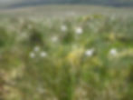
A transiton from moor to woodlands ablaze with wood anemone takes me to the start of the popular Cautley Spout ascent. With supplies low I cross the river to visit the Cross Keys.
The Cross Keys – a pub and inn – is one of the UK’s first (and still, only) temperance inns. Built in the 16th century, the farmhouse was converted to a public house somewhere back in the 1800s. But the liquor license was not to last long. Whether it was down to the area's growing Quaker influence (in 1652 George Fox preached to a congregation of a thousand on Firbank Fell, just the other side of the Howgills from here), or the non-conformist ideas of one-time owner Colonel Gervase Benson, or the tragic drowning of a former landlord attempting to rescue a young drunken visitor from the Rawthey (the young man's family subsequently bought the inn and wrote into its deeds that it could never sell alcohol again), by the opening years of the 20th century the Cross Keys had relinquished its license.
I enter from the road under a plaque that reads: “H 17: J A :30” – the initials and date refer to John and Agnes Howgill (now there's a local name!) who owned the property – to a jumble of low-ceilinged passages and tiny rooms; in one is a perfect recreation of a farm kitchen circa 1800; in another swing music plays in an airy conservatory with panoramic views of the mile-long rip of Cautley Crag.
There’s not a soul in the place.
I continue further into the interior, where there’s noise of industry: a kitchen with an Aga and pots and pans stacked in ordered chaos.
Might I get a drink, I ask?
I am told to take a seat in the riverside garden.
I make my way around the pub to a gated garden out back. It has an allotment growing greens and hens that pick grubs from the grass as swallows dart over the bubbling Rawthey. There I face two choices: which of 40 or more non-alcohlic drinks would I like? (Elderflower cordial.) And which of 20 cakes? (Chocolate.)
If anything was going to keep me on the temperate/sugar-high straight and narrow for the final mile-and-a-bit to Sedbergh cordial and cake felt like they should do the job better than most.


I meet Terence just above the blazing gorse bushes that flank Cock Brow.
It’s an amiable hour to Sedbergh from here, the PJ taking old farm tracks, terraced hillside sheep trods and meadow paths. More bluebells – in woodlands, on fellsides, along roadsides – show that nature works wonders the finest Chelsea designer can only dream of, the unfolding centuries gifting us unending wild gardens in which walkers are lucky enough sometimes to play.


We visit Terence's mum and dad on the final wander into town.
There’s tea in abundance – and more cakes than at the Temperance Inn; Mrs Stephenson’s been busy baking.
Mr S, meanwhile, is talking agriculture.
Until 70 he farmed the lower flanks of Baugh Fell.
Times weren't easy, he recalls. Particularly on sweltering days like this.
WIth no water in the barns the cattle would have to be untied, one by one each morning, then walked onto the fellside to drink from the beck. When they’d had their fill they’d be bought back. The same routine happened again in late afternoon.
200 cattle. Twice a day. And that was before work got started on the myriad other farming tasks.
Us soft southerners wouldn't know where to start.
I resist the urge to tell the family about my interactions with the Baugh Fell herd four hours earlier and instead reach for another slice of Mrs T's fine lemon sponge...


Continue the Pennine Journey: Day 16 - Sedbergh to Ingleton.
Back to Pennine Journey.