Horton in Ribblesdale to Hawes
- Dave
- Jul 17, 2019
- 5 min read
Updated: Jan 28, 2020
Pennine Way - Day 7 - 14.3 miles - 'Droveroads'
It's not often that I set off harbouring a general feeling of dread.
But heavy rain and high winds had been forecast for the next three days, during which time I'll be climbing high-level moorland passes. Not just that – I'll be climbing them in new boots and if I was a betting man I'd wager at least one blister by the week's end.
In the end, although the weather was grim the walk didn't demand too much – a short if bleak sojourn over lonely tops on well-graded droveroads – and my kit upgrades got a road test. More importantly, I reached Hawes in time for lunch and an afternoon of more enjoyable road-testing. Beer this time around.
As ever, all feels brighter after the first couple – even if the sky's stuck stubborn grey.

I can't remember the last time I was out the door by six.
Nor the last time I set off in full waterproofs.
Not the most auspicious return to the road after two days rest (during which the weather was, typically, fine).
Still, the walk must go on, and I was onto the trail before most people in Horton had even opened their curtains. I didn't blame them. If ever there was a reason for a duvet day, this was it.
I spent the first ten minutes in the public loos in Horton waterproofing myself. iPhone in drybag meaning a day map reading old-school style. Waterproof top and trousers. And, for the first time in my life, gaiters.
Coupled with my new boots and socks I felt like I'd received a computer game power-up; Dave 2.0.
Then – deep breath – it was time to leave the closet, as it were, and do battle with the wind and rain.

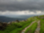
The route today was about as straightforward as the Pennine Way gets: a simple up-and-over of sprawling Cam Fell to the village of Hawes using the old droveroads.
These are the roads shepherds and farmers once used to drive cattle between valleys. Some stretch back to Roman days, many earlier. For the walker they give easy passage: the grading is kind and even in poor visibility there's no chance of wandering astray.
On a fine day you could imagine skylarks would sing you home. Today, hood up, the sound was mainly water: punctuation of driving rain, rush of swollen rivers and streams for paths. More than once I had to detour to find the least wet passage over a waterway that had burst its banks. In the precipitous confines of wooded Ling Gill the falls were thundering down.
Water, water everywhere.
The water I could deal with. But the wind ups the stakes. On the moor there's little shelter: no trees, no hedges, few walls – just this solitary walker taking the full force of the Pennine crosswind.
I don't know whether it's because I've got a short memory or because I'm a fair weather summer walker, but it still surprises me how bitterly cold you can get on the heights in June. By lunchtime, finding something close to shelter behind a rare stone wall above lonely Camm Farm, my fingers were numb. I was grateful when the rain finally eased above Grove Head.


As the miles passed on the same incline I was struck again by the scale of the Dales. These may not be big heights, but they are big hills. Hills that stretch for miles and miles, so that you can find yourself resting for lunch without having lost a foot's worth of height.
Uphill all the way.
The giant footprints of these peaks open up panoramas that are as big as the sky. Behind, the Yorkshire Three Peaks, ahead Wild Boar Fell and tomorrow's goal of Great Shunner Fell. (There are some nice names of nearby hills too: Muker Common nestling beside Lovely Seat.)
Best of all, framed between cloud-topped Ingleborough and Whernside, the distant Ribblehead Viaduct.


The Ribblehead Viaduct – or Batty Moss Viaduct – is the jewel in the crown of the Settle to Carlisle line, probably the most remote stretch of railway in England.
The 73 mile feat of engineering – seven years in construction – is a tale of grandiose vision, brutal politics and human tragedy. An army of over 6,000 skilled navvies from around Britain were employed to build the line, living in shantytowns that sprung up on the wretched moors below. The towns were given names that showed a dark sense of humour: Sebastopol, Jericho, Belgravia.
The names did nothing to lift the grimness of the surroundings or life in the camps, which was beset by overcrowding, disease (mainly smallpox), drunken violence and the ever-present snows, wind and rain.
Around 100 navvies died during the construction of the viaduct's 24 grand limestone arches. Many more did so toiling on the line. The graveyard in Chapel-le-Dale had to be extended to cope with 200+ graves and a memorial to the unnumbered unknown – including wives and children of the masons and labourers. It wasn't uncommon for men to simply collapse on the moor staggering home from the Welcome Home Inn to be buried where they fell.
A victory of dogged persistence over landscape, conditions, finances and human lives. Even three miles distant it's an impressive sight.

On and on, one wet step at a time as the distant hills, all grey, so slowly change.
I sing to myself to bring music to the gloom.
When I say myself, I mean out loud – but there's no one ever around, just me and a few sheep.
I don't seem to have much control over the songs that come. On the joyful approach to Pen-y-ghent on Sunday it was the banjo line from The Manchester Rambler. Which, after the first few renditions, started annoying me, sole member of the audience.
Today, boots picking through rain-glazed rock and stone, heavy load, and still miles from Hawes, I find myself singing Little Donkey.


Before passing the Welsh couple at the end of last week, I'd almost given up hope of meeting LeJogers heading south (JogLers).
Then today another two. This time a father and son on the ultimate family bonding exercise.
They're doing it properly. Not just camping, but they spent the first two weeks in the wilderness of Scotland on the mighty Cape Wrath Trail.
Respect all round. And they were still smiling.


Down the long shoulder of Ten End, through the hamlet of Gayle and I arrived in Hawes, my break point for the day.
It's your quintessential Dales tourist town: stone houses that are used to the elements, a dozen tea shops and lots of parking for buses. Hawes has the added draw of the Wensleydale Creamery: makers of the eponymous cheese that has been made in this valley since French Cistercian monks from the Roquefort region settled in the Yorkshire valley in 1150-ish, bringing with them a recipe for the yellow stuff.
In his LeJog guide, author Andy Robinson urges all who pass through Hawes to buy a chunk of the cheese. I'd need no persuading, of course (nor can you escape it; woe betide the Hawes baker who attempts to put anything but Wensleydale in their cheese sandwich!), but these days the cheese needs no charity.
In 1992 Dairy Crest closed the Hawes Creamery with a loss of 59 jobs (boo) , bringing to an end the dale's nine-century association with cheese (double boo) and transferring production to over-the-border rivals Lancashire (triple boo).
Six months later a management buyout saw the Creamery reopen (yay). Sales continued to rise (double yay), helped in part by an unlikely association with Wallace and Gromit (triple yay). When Curse of the Were-Rabbit was released in 2005, sales of Wensleydale cheeses increased by 23%. The company is now a major tourist attraction, employing 190 locals and buying milk from 36 farms in the valley.
Which makes every crumbly slice of the cheese taste that bit better.
Doing my bit in this sock-it-to-the-big-man success story I have invested in Wensleydale and biscuits for afternoon tea, veggie burger with Wensleydale for dinner and I have no doubt Wensleydale will find itself incorporated somehow into my breakfast tomorrow morning before another day of soggy up and downs.


Back to Pennine Way
Continue the walk: Day 8 - Hawes to Keld